The parish has an extensive network of public rights of way, mostly footpaths, but also some bridleways. Because it is ‘long and thin’, several walks pass through the parish (e.g. The long-distance Minster Way) or, if circular, wander into neighbouring parishes. A number of minor roads are single-track and traffic-light and can be used to connect the off-road paths. Particularly attractive for walking is the well-wooded landscape that surrounds the village of Kilnwick, a legacy of the Grimston’s Georgian country estate.
If you're interested in local landscape history click here
Circular Walks from Kilnwick
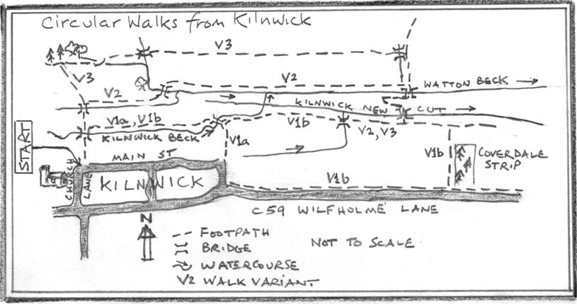
Map: OS Landranger Sheet 106 (Market Weighton)
Start: Main St, Kilnwick (National Grid Reference SE997496)
Finish: Main St, Kilnwick (National Grid Reference SE997496)
Description: gentle walks of 1, 2, or 3 miles, rising and falling only a few metres, taking in wet meadows, pasture, arable fields, carr and woodland. A short stretch of carr means that Wellington or hiking boots are desirable except in dry summers. In winter, soils will be squelchy in places.
Directions: Set off from the west end of Main St at its junction with Church Lane, close by All Saints’ Church, and follow the signpost northward down the green lane, crossing Kilnwick Beck. Now choose:
- Variant 1). Immediately north of the Beck, turn eastwards (right), following the stream. After 650 yards, enter a covert and cross the bridge. From here:
- Variant 1a (1 mile): turn southward (right), returning to Main St at Tibby Corner. Turn westward (right) onto Main St and return to the start point.
- Variant 1b (2 miles): turn north-eastward (left) and follow the woodland boundary. Continue along the woodland edge for 750 yards until reaching a vehicle track on the right. Turn onto the track, passing Coverdale Strip woodland, to reach Wilfholme Lane. Turn westwards (right) and follow the pedestrian roadside path, turning right into Tibby Lane. Follow the road round to where it becomes Main St and walk back to the start point.
- Variant 2 (2 miles). After crossing Kilnwick Beck from the green lane, continue north and cross the bridge over Horse Carrs Dyke. Through the gate, turn eastward (right) and follow the hedge, veering leftwards towards some mature trees. Pass through the gate, cross the bridge over Watton Beck, and, once through another gate, turn eastward (right). Follow the beck for 1100 yards and turn south (right) to cross the beck. Immediately turn westwards (right) and follow the beck for 175 yards. Here, the path turns southwards (left) and crosses wet carr (there are some old railway sleepers to help). The path winds a few tens of yards through some thorn scrub and leads to a bridge over Kilnwick New Cut. Climb the bank and immediately turn westward (right). Follow the woodland edge for 425 yards, crossing a bridged dyke partway, until you come to the bridge over Kilnwick Beck. Cross the beck and follow it for 650 yards until you come to the signposted bridge. Turn south (left) over the bridge and go up the green lane to the start point.
Variant 3 (3 miles). After crossing Kilnwick Beck from the green lane, continue north and cross the bridge over Horse Carrs Dyke. Through the gate, strike northwestwards (veer left) heading for woodland. On reaching the woodland edge, turn eastwards (right) for a 100 yards, pass through a field-gate opening on your left and turn right. Pass through a gate and cross a bridge. Continue eastwards for about 980 yards, following the hedge, to pass through a gate and cross a bridged dyke. Immediately turn southwards (right) and follow the path down to the bridge over Watton Beck. Immediately turn westwards (right) and follow the beck for 175 yards. Here, the path turns southwards (left) and crosses wet carr (there are some old railway sleepers to help). The path winds a few tens of yards through some thorn scrub and leads to a bridge over Kilnwick New Cut. Climb the bank and immediately turn westward (right). Follow the woodland edge for 425 yards, crossing a bridged dyke partway, until you come to the bridge over KIlnwick Beck. Cross the beck and follow it for 650 yards until you come to the signposted bridge. Turn south (left) over the bridge and go up the green lane to the start point.
Return to list of walks
Lund and Back
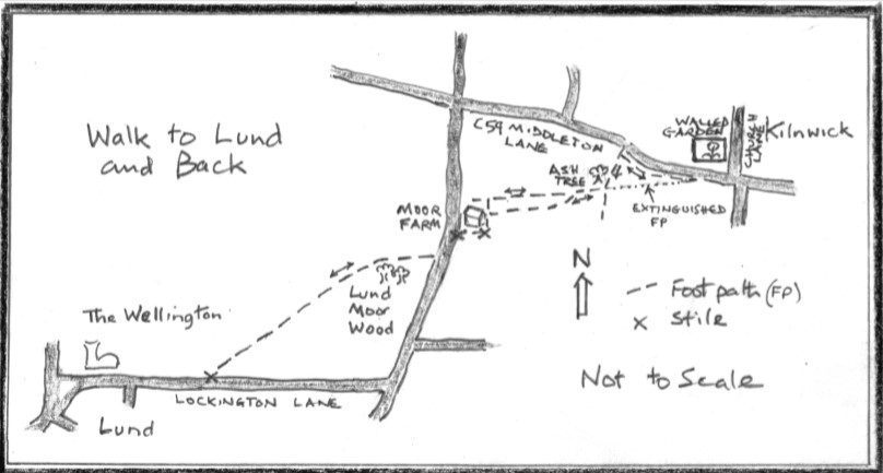
Map: OS Landranger Sheet 106 (Market Weighton)
Start: Junction of Church Lane and Middleton Lane, Kilnwick (National Grid Reference SE996494)
Finish: Junction of Church Lane and Middleton Lane, Kilnwick (National Grid Reference SE996494)
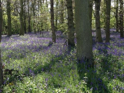
Description: This is a ‘there-and-back’ walk from Kilnwick to Lund. It takes in the amazing sight of the blue bell carpet in Lund Moor Wood – during March through April, depending on spring weather – and, at the furthest point, there are the celebrated refreshments of The Wellington Inn.
Lund and back: 4.2 miles; or Lund Moor Wood and back: 3.2 miles.
Directions: The walk starts in Kilnwick at the junction of Church Lane and the C59 (Middleton Lane) at the SE corner of the magnificent, listed Walled Garden (National Grid Reference: SE996494). From here, go westwards (turn right out of Church Lane) on the C59 for about 100 yards. Go through a farm gate on the south side of the road, opposite the SW corner of the Walled Garden).
Once in the field, the footpath runs westward along the roadside hedge. Note: on older OS maps, the footpath strikes out just a few degrees south of west, heading for a solitary ash tree at the far side of the field (N.B. ash die-back is yet to take its toll in the Parish, February 2020); this has been extinguished and the route along the hedge is now the designated Public Right of Way. Trek west for 400 yards until you come to a second gate opening and a way-marked footpath. Head SW for about 100 yards and arrive at the ash tree mentioned earlier. Here, turn WSW (rightwards), passing through the gateway (no gate!). After about 100 yards, the footpath veers SW across the field towards the NE corner of Moor Farm buildings (there is no way-mark). However, this path is never restored after sowing. So, you may prefer to continue along the line of the hedge (a designated Public Right of Way) for about 400 yards until the onward path is confined by a hedge to the north and a fence to the south. Here, take an abrupt left turn southwards and skirt the fenced paddock, heading for the farm buildings. (This short stretch is not a right-of-way, but the farmer – Mr Wayne Smith – might rather have your boots on the edge of the field than following the Public Right of Way across it).
Once in the vicinity of the farm buildings, you will have regained the right-of-way and you will see a way-marker directing you rightwards (west) over a stile and through a paddock. Cross another stile at the far side of the paddock and turn south (left) down the minor road for about 100 yards. Here, just to the north of Lund Moor Plantations and on the west side of the road, take the way-marked path. After about 100 yards, you will have arrived at Lund Moor Wood, where, in March through April, you can feast your eyes on an acre or more of densely flowering blue bells. Of its kind, this seasonal display is as good as you’ll see anywhere in the British Isles – and, you’re more than likely to have it all to yourself.
If you’re bent on refreshments in Lund, continue walking for about 50 yards SW and pass through a gap in the hedge at the western end of the woodland. From here, strike out – still southwestwards – diagonally across the field, passing through a hedge and continue southwestwards across another field. The path in these fields is usually restored after sowing. Pass through a pedestrian gate and turn west (right) onto Lockington Lane (unclassified). After quarter of a mile you’ll have reached The Green in Lund and, of course, The Wellington Inn (click here for website). If you're planning refreshments, check out opening times before starting out and time your walk accordingly.
Once refreshed, return by the same route as you came.
Return to list of walks
Southbelt Plantation & Kilnwick Beck
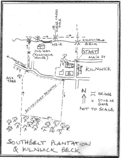
Map: OS Landranger Sheet 106 (Market Weighton)
Start: The Junction of Church Lane and Main Street, Kilnwick (National Grid Reference SE997496)
Finish: The Junction of Church Lane and Main Street, Kilnwick (National Grid Reference SE997496)
Description: This is a short circular walk taking in the woodland legacy of the Kilnwick Estate, together with Kilnwick Beck and its modification for aesthetic and practical purposes. In winter, there will be places where ground is muddy, even soggy. Topography is gentle and the imperceptible rise and fall is no more than 30 feet.
The distance is 2 miles.
Directions: Set off westwards from the junction of Church Lane and Main St, passing through a wrought-iron gate that appears to lead into a garden (the way-mark is on the opposite side of the road). This takes you onto a gravel path that swings around to All Saints Church. After about 20 yards continue straight on through another wrought-iron gate. (The gravel path swings to the south – leftwards; avoid this unless you wish to inspect the church, parts of which are Norman). Pass through the woodland and emerge into a field (known as The Park, Kilnwick – a 6.5 acre community asset that includes extensive tree planting). Straight ahead is what remains of Kilnwick House, one of the seats of the Grimston family until the first half of the 20th Century. You will see more of this later. In the meantime, turn south (left) and, after 60-70 yards, skirt The Willows by turning west (right) and then south (left). After 60 yards or so, you meet the C59 Middleton Lane. Turn east (left), noting the 18th century brick-lined ha-ha that lies in front of The Willows, and, after about 60 yards, on the south side of the road and across from the SW corner of the late-18th century Walled Garden, you will see a gateway in the hedge-line.
Pass through the gateway and strike out southwards long the hedge-line. Note that older printed OS maps will show the bridleway running diagonally, southwestwards across the field; this route has been extinguished and a field-edge alternative has been designated as the Public Right of Way. You are heading for Southbelt Plantation, one of several extensive woodland coverts that owe their existence to the former importance of the Kilnwick Shoot. The wood has a legacy envelope of beeches that sandwiches more recent plantings of ash and cherry. An invasion of birch provides further diversity. Just north of the woodland turn right (west) and follow the boundary until you reach the next field hedgeline. The bridleway continues directly southwards through the Plantation (and can be muddy in winter). If you’re stealthy, you might catch a glimpse of Roe or Sika deer. Once you’ve explored the wood, retrace your steps to the northern edge and follow the way-marked footpath that runs northwards along the hedge on the west side of the field that you have skirted from Kilnwick Walled Garden.
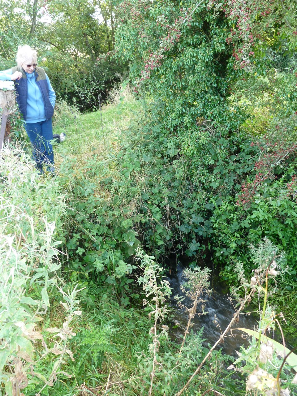
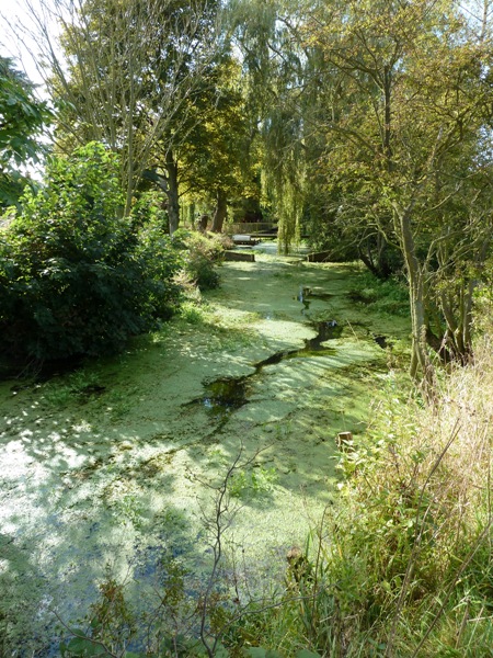
After about 500 yards, you reach a gate-way and the C59 (Middleton Lane). Go directly across the road and walk down a tarmac drive (way-marked). Where the drive turns east, go straight ahead through a gate and continue along the same heading across the field. Here, step over a stile and cross Kilnwick Beck by the foot bridge. Emerge from the riparian thorn-scrub into a field and turn east (right) immediately. It can be very muddy here in winter, but you can usually negotiate a route if you haven't got Wellington boots! Follow Kilnwick Beck, crossing a small foot bridge over a ditch. To the south is what remains of one-time Georgian Kilnwick House. What you see are the living quarters, which predate the Georgian façade, itself now demolished, parts of which are Jacobean. Continue eastwards, passing an impoundment of the Beck, which provides a water garden for Kilnwick Beck House. Further east after 60-70 yards, the path wiggles and you become aware of the sound of falling water. A small deviation off to the south across a recently cut overspill channel reveals the weir that creates the backwater for the water garden. Retrace your steps to the path and pass through an opening in the hedge-line. Somewhat innocuous is a brick-lined take-off that lies under the path. This feeds Horse Carrs Dike (which drops to your left); this was once important for diverting water from Kilnwick Beck into Watton Beck and played a role in keeping Watton Corn Mill turning.
Walk east for a further 100 yards and turn south (right), crossing Kilnwick Beck (way-marked). Follow the ‘green lane’ for about 200 yards until you reach Main St, Kilnwick, and the point from which you started.
Return to list of walks
Kilnwick to Watton Mill and Back
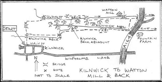
Map: OS Landranger Sheet 106 (Market Weighton)
Start: Main St, Kilnwick (National Grid Reference SE997496)
Finish: Main St, Kilnwick (National Grid Reference SE997496)
Description: a gentle walk of about 3 miles, rising and falling only a few feet, taking in wet meadows, pasture, arable fields, carr and woodland. In winter, soils will be squelchy in places.
Directions: Set off from the west end of Main St at its junction with Church Lane, close by All Saints’ Church, and follow the signpost northward down the green lane, crossing Kilnwick Beck. After crossing the beck, continue north (straight on) for 100 yards, or so, and cross the bridge over Horse Carrs Dyke. Through the gate, turn eastward (right) and follow the hedge, veering leftwards after 60 or 70 yards towards some mature trees. Pass through the gate, cross the bridge over Watton Beck, and, once through another gate, turn eastward (right). Follow the beck for 1100 yards and turn south (right) to cross the beck. Immediately over the bridge, turn eastwards (left) and follow the beck for about 800 yards.
The beck has been straightened and gradually rises above the valley bottom by a few feet, contained by raised banks or levées. The purpose of this is to create a head of water for Watton Mill, which is the first building you meet, lying on the opposite side of the beck from the path. The mill no longer functions and is a private dwelling. But if you look upstream towards the building, you’ll see the culvert through which water passed after it had turned the breast-shot wheel. Look through the water immediately downstream of the mill house and you’ll see several, discarded grind stones, whilst another stone lies propped against the building.
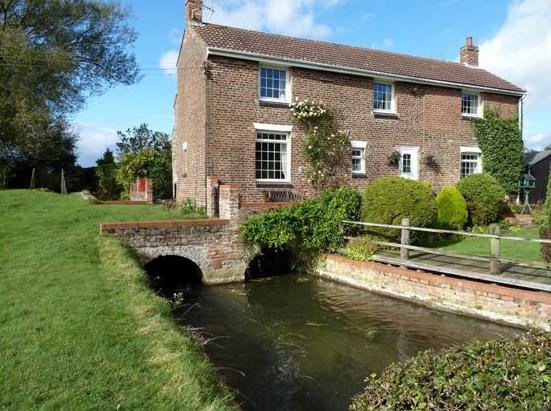
Watton Corn Mill, now a private dwelling. The mill race culvert lies rightwards.
Fifty yards or so downstream from the mill house and well before you reach the A164, take the path through a fence to the right (south-southwest). This path is not always restored after sowing and can be a trifle boggy in places. An alternative is to walk further along the beckside path until you reach the A164 and turn right (south-southwest) along the roadside tarmac path. Both pathways converge on the A164 opposite Fountain Farm, having crossed Kilnwick New Cut. Turn right (west-northwest) onto the footpath and follow the Cut, which is a straightened channel dug in the 19th century roughly along the line taken by a precursor of Watton and Kilnwick Becks and was designed to ensure drainage of the bottomland. After about 600 yards, skirt the south side of the valley bottom woodland - Tall Trees and Low Wood - for about 800 yards before turning right in order to cross the footbridge over Kilnwick Beck. Follow the beck westwards for about 600 yards until you recognize the bridge that leads to the green lane along which you started the walk. Turn left (south) over Kilnwick Beck and, after 250 yards, find yourself back on Main Street Kilnwick.
For more information about Watton Corn Mill and the manipulation of the water courses which provided the means to turn its wheel, see: River Hull Drainage Heritage Group 2014 Becks,Banks, Drains and Brains – The Drainage History of the River Hull Valley. 2nd Edition. East Riding of Yorkshire Council. ISBN 978-0-9552912-1-0.
Return to list of walks